Last Monday (29 July) was another perfect day in paradise, so we just had to go for another ride. The Wellington International Film Festival is on, and I was going to go and see a film, but couldn’t justify sitting in a darkened theatre on such a glorious day.
We had been wanting to ride along the Wellington waterfront for a while, but we decided to delay it until after the school holidays so that there would be fewer people about. For the same reason, we thought we should start our ride a bit earlier in the day than we have been doing lately, so as to avoid getting in the way of all the lunchtime walkers and joggers that were sure to be out on a sunny day.
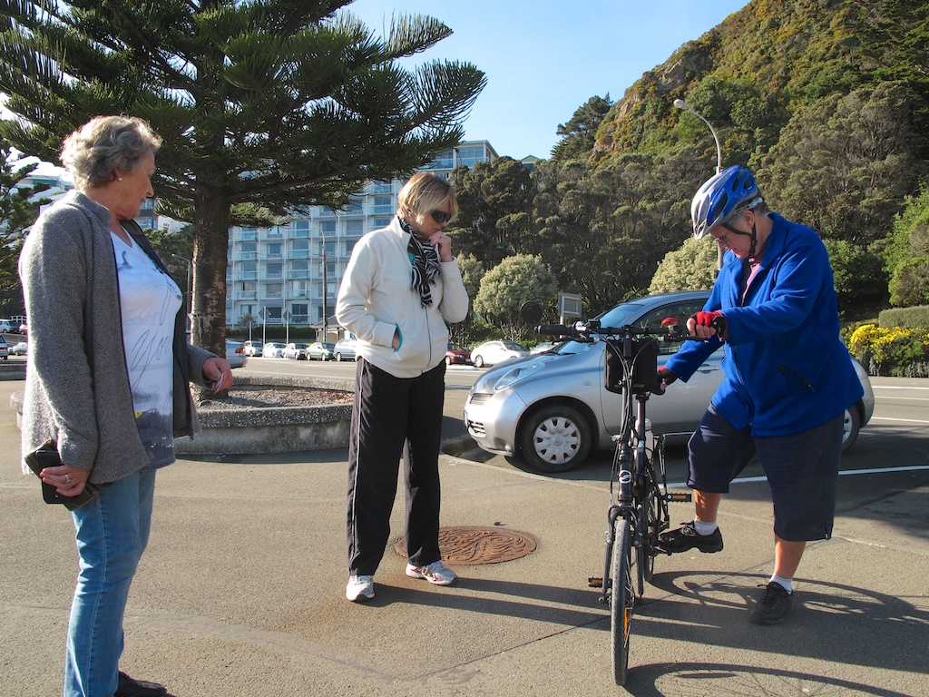
So at 10:30 we parked at the far end of Oriental Parade, and as we were getting ready, two ladies came up and asked us about our bikes. They commented on their handy size, and marvelled at the fact we were able to fit them into our little car. They thought our rear-vision mirrors, odometer/computers, and bells were brilliant. “All bikes should automatically come with mirrors and bells” they said. John mentioned my blog and I gave them the blog address.
 |
| They were interested in our folding bikes (photo by John) |
We set off along Oriental Parade, towards the city. The wide footpath is one that can be shared by cyclists. Riding-wise, it is uneventful, being smooth and flat all the way. So this blog post is going to be more about the sights and the photos we took, than about the riding. It will be a bit of an
“Ode to the Wellington Waterfront”.
 |
| The wide footpath along Oriental Parade (photo by John) |
From here, the view to the city is blocked by the construction of the Clyde Quay Wharf Development, jutting out into the harbour. This used to be the Overseas Passenger Terminal, designed by Sir Michael Fowler (later to become Wellington’s mayor) in the early 1960s, to berth overseas passenger ships. My sister-in-law Diane left from here on her
big OE in 1966. The Overseas Terminal hasn’t been used for such ships for many years, as by the late 1960s, air travel became more popular and affordable. Nowadays, with the resurgence of ocean cruising as a holiday destination, the cruise ships are so huge, they now berth at Aotea Quay, opposite the Stadium.
Now the old terminal has been demolished, the pier has been extended, and 75 luxury apartments are being built on this prime site. I’m not sure I like it. To my feeling, it’s too much like Auckland, and pandering to the almighty dollar. It spoils the views for everyone, for the sake of the privileged few.
 |
| The former Overseas Terminal will become the site of luxury apartments |
Close to the new development, and parallel to it, there is a short pier from the end of which we had a great view up to St Gerard’s Monastery, on Mount Victoria, high above Oriental Bay. It is one of Wellington’s most distinctive landmarks. It was built in 1932 for the Redemptorist monks, and is now owned by the International Catholic Programme of Evangelisation, who use it as a retreat and training centre. The building is registered with the NZ Historic Places Trust.
Sadly, with NZ’s increased focus on ensuring that buildings are earthquake resistant, it has been identified as an earthquake risk, and it was recently confirmed that it will cost ten million dollars to bring St Gerard’s up to the required standard.
 |
| St Gerard’s Monastery (photo by John) |
Next to the jetty is Freyberg Beach, a small man-made beach built in 2004. While in the early days, there was a small beach at Oriental Bay, it was subject to erosion, so in 1944 the main beach was “renourished” by the importation of 10,000 tonnes of sand to make the area more attractive. In the early 2000s, another 22,000 tonnes of sand were barged across Cook Strait from Golden Bay. The level of sand is monitored, and more sand is added when required.
Wellingtonians love Oriental Bay, and on a warm summer’s day it is a very lively place indeed, with people on the beach, others strolling or cycling along the footpath, some resting on the many seats along the seawall, or enjoying the various cafés across the road.
 |
| Freyberg Beach is man-made from sand imported from Golden Bay (photo by John) |
Along the front of the Freyberg Pool (Wellington’s original indoor pool, built in 1963), there is the counter of Bernie’s on the Bay Café. The pavement café is named after a gorgeous Bernese mountain dog, Bernie. I tried to get him to look at me for a photo, but he was more interested in what was going on at the counter.
I am very partial to these kinds of dogs, as they were very common in Switzerland, where I lived during my teens. In fact, we had a dog of a related breed, an
Appenzeller, who eventually travelled with us to NZ, and lived to the great old age of 16 years. His name was Dikkie (“dik” being Dutch for “fat”, as he was rather chubby as a pup).
 |
| Bernie, the Bernese mountain dog, at Bernie’s on the Bay Café |
Along, past the Port Nicholson Yacht Club and the Chaffers Marina. Here the former Herd Street Post & Telegraph building occupies a prime position overlooking the marina. It was converted to luxury apartments in 2007. I sometimes think the roof-top penthouse would be a great place to live. Great views, no chance of being built out, walking distance to the city. The only drawback would be the price: I saw one of the penthouse apartments advertised for sale for the eye-watering BEO (Buyer Enquiry Over) price of 4.25 million dollars!
 |
The former Herd Street Post & Telegraph building, now converted to luxury apartments
(photo by John) |
There are several sites for cafés or restaurants on the ground floor. It’s such a great place to have a coffee and watch marina activities and people strolling past, but for some reason none of them seem to be able to make a go of it. Could it have something to do with the quality of the coffee served in some of these places? The last coffee I had there some months ago was like dishwater. Currently, the sites are all empty!
The Chaffers Dock has haul-out facilities for vessels, and when we went past, one of the
East by West harbour ferries was up out of the water and being attended to.
 |
| East by West Harbour Ferry in the dry dock (photo by John) |
Along the front of Te Papa, or to give it its full name, the Museum of New Zealand Te Papa Tongarewa, then around the wharf towards the city. A favourite sculpture,
"Solace in the Wind" by Max Patté (2007), looks like he is leaning against Wellington’s famous wind, before diving off the wharf.
In the photo below, there are several interesting Wellington landmarks in the background: from the left, the Michael Fowler Centre, a concert hall and convention centre; the crane of the
Hikitea, a floating crane; the Majestic Centre, the tallest building in Wellington; the Wharewaka in front of it (more about this building later); the Star Boating Club (the half-timbered building) and the Boatshed, both also convention venues (you may need to enlarge the picture by clicking on it, to see those details).
 |
| "Solace in the Wind" (2007), by Max Patté (photo by John) |
We rode past the Te Papa forecourt, onto the Taranaki Street Wharf, and past the
Hikitea. This is the only working, floating, steam-powered heavy-lift crane in the world, and it is still working hard. As recently as April this year, it was used to lift sections of a crane from the Overseas Terminal construction site. It was also used in the dismantling and salvaging of the interisland ferry
Wahine, which sank in Wellington Harbour in 1968 (mentioned in my Pencarrow blog posts).
 |
| The Hikitea (photo by John, November 2012) |
Across a footbridge over the entrance to the Frank Kitts Park Lagoon, and in front of
Frank Kitts Park. This park was named after Wellington’s longest serving mayor (1956-1974), Sir Frank Kitts.
Past Queen’s Wharf, the site of several restaurants, and on to the Kumutoto Wharf area, where there are more eateries. Several are housed in what was once the Steamship Wharf building, which later became the Greta Point Tavern. This late 19th century historic building was saved from demolition by being moved from Evans Bay to its current site by barge in 12 pieces in 2003.
Behind this building, the City Council constructed some very fancy toilet facilities, popularly known as the
“Lobster Loos”. They were completed in 2011, in time for the influx of visitors for the Rugby World Cup. In 2012, the designers, Studio of Pacific Architecture, won an architecture award for their functional and interesting design. “A great mix of art and design”, the jury said. The toilets have attracted a lot of comment, both favourable and unfavourable. Apparently they’re very swish inside, but I haven’t yet had the opportunity (or need?) to check them out.
 |
| "Lobster Loos" (photo by John) |
Around the next building is
"Nga Kina", a sculpture consisting of nine giant kina shells, by Michel Tuffery. It was installed at the end of 2012. A
kina is a sea urchin, native to NZ. It is considered to be a delicacy by many Māori. When it is alive, it is covered in sharp spikes which protect it from predators. Presumably, the spikes fall off after it dies, which then leaves a pale green shell with delicate patterns.
 |
| "Nga Kina" (2012), by Michel Tuffery (photo by John, January 2013) |
From here we rode without any stops along the Waterloo Quay waterfront, past the Bluebridge ferry terminal and the Railway Station, and along Aotea Quay to the end of the foot/cycle path on this side of the road. The last stretch runs under a lovely canopy, consisting of glass panels etched with a fernleaf design. It runs between the Westpac Stadium on one side, and CentrePort and the Aotea Quay cruise ship terminal on the other.
It is a 1.5km walk into town for cruise ship passengers, and until about two years ago, the area was not very attractive. The canopy was installed to protect walkers from the weather and from the sight and smells of the logs that are stored in this area, waiting to be shipped overseas. It was part of the beautification of Aotea Quay, and was completed just in time for the Rugby World Cup in 2011.
 |
| The Westpac Stadium, also known as “The Cake Tin” |
The foot/cycle path ended here, so we turned around. On our way back we decided to go up the ramp to the Stadium Concourse. To get to the ramp, we passed a sculpture outside the former offices of the NZ Rugby Union. The statue by French sculptor Stéphane Cipre is titled
"Les contre-valeurs du rugby" (the values that rugby is opposed to), and it depicts two rugby players in a scrum against a wall of words: disrespect, lack of discipline, selfishness, drugs, cheating, racism, and individualism. It was donated by France and
unveiled by the French ambassador in October 2011, at the time of the Rugby World Cup.
France and NZ are great rugby rivals, in a friendly way. As it happened, the World Cup final was between NZ and France, and in a nail-biting game, NZ won 8-7. I’m not a rugby follower at all, but I joined John in watching the last few games of the Cup on TV, and the final was quite exciting, even for someone as ignorant about rugby as me.
 |
| Rugby sculpture, donated by France, at the time of the 2011 Rugby World Cup (photo by John) |
The green building in the background of the above photo houses Statistics NZ, where I worked on a six-month contract as one of the editors of the 2008 NZ Official Yearbook. It was the second-to-last Yearbook to be published in printed form, 2010 being the last. In 2012, it was decided to discontinue hard copy Yearbooks in favour of online publication.
And so, up the ramp to the Stadium Concourse. The stadium adjoins the Wellington railway station, and the concourse is designed to allow people to flow out of the stadium straight to the trains and buses. There are also 850 carparks underneath, though it would cost you "an arm and a leg" to park there for an event. The concourse is a vast expanse of smooth concrete and it was superb to ride on. It is 650m long and 14m wide. Apart from one or two people strolling, it was deserted. We were able to go hooning around like a couple of kids, fabulous fun!
 |
The Stadium Concourse provides easy access to public transport after attending an event
(photo by John) |
The concourse is called
Fran Wilde Walk, named after Fran Wilde, former MP (1981-92) and Minister, former Mayor of Wellington (1992-95), and now Chair of Wellington Regional Transport Committee. At its official opening in 2000, the then Mayor, Kerry Prendergast, said that naming the walkway into the Stadium the
"Fran Wilde Walk" was a fitting tribute to the dedication, determination and commitment of Ms Wilde to ensure Wellington got a new stadium. There are two information columns on the concourse providing insights into the history of the stadium and the concourse.
From the concourse, above the railway yards and the roads, we had great views on all sides. On the sea side we could see the logs piled up on the wharf, waiting to be exported, and the start of the covered walkway we rode under.
 |
| Logs waiting to be loaded, and the start of the covered walkway |
There is also the Harbour Quays BNZ Centre, which has been in the news lately for having suffered serious damage in the 6.5 earthquake that rocked Wellington on Sunday 21 July. Yep, Wellington is a happening place – first storms, now earthquakes, but it’s still the “coolest little capital in the world!” (Lonely Planet’s 2011 assessment of Wellington).
Being built on reclaimed land, the BNZ building probably got the worst of the shake. Despite being only four years old, and having supposedly been built to stringent modern earthquake resistant standards, it appears that the ceiling panels had not been attached with these standards in mind. Many of them crashed down, rupturing firesprinklers on the way, and thus causing a great deal of water damage. Apparently it was to take eight weeks of repairs before the building could be occupied again.
 |
| The Harbour Quays BNZ Centre |
On the city side we could see the trains, waiting in readiness for the peak hour exodus of workers heading home.
 |
| Trains, ready for the peak hour exodus |
There is also a view towards the bus terminal, with its yellow GO Wellington buses (gold and black are Wellington’s colours), and with the “Beehive” in the background. The
Beehive is the executive wing of the NZ Parliament buildings. It was completed in 1979, and it houses the offices of the Prime Minister and Cabinet Ministers.
 |
| The bus terminal, with the Beehive in the background |
After doing a few more circuits of the concourse (to increase our kilometre count!) we headed back down to Waterloo Quay. This time we went round the side of the Statistics NZ building onto the waterfront. Past a gated, locked wharf full of shipping containers, and to the wharf that is the home of Wellington’s three red tug boats,
Toia,
Ngahue and
Tiaki. They were all in port when we rode past, and they provide a bright splash of colour.
 |
Toia and Tiaki, two of Wellington's three tugs (photo by John)
|
Tied up at the next wharf were the police launch, the
Lady Elizabeth IV, a state-of-the-art catamaran, and a smaller police boat. They are part of the Wellington Police Maritime Unit, which is based in the Old Ferry Building on Waterloo Quay’s service jetty. Sadly, when the building was refurbished, it seems they removed the lovely name plaque that used to adorn it.
 |
| The catamaran is the Police Launch Lady Elizabeth IV (photo by John) |
 |
| The Old Ferry Building now houses the Police Maritime Unit and National Dive Squad |
 |
| This lovely plaque used to be on the building before it was refurbished (June 2010) |
Opposite the Maritime Police Unit is the Wellington Waterfront Motorhome Park, a facility for overnight parking specially for campervans. I thought the designs on the doors of the modern, and rather attractive, ablution block were quite amusing.
 |
| His and hers |
Back across the Kumutoto Bridge, with its support that resembles a crane, past the mooring of the
East by West Ferry, which offers an alternative means of commuting to the residents of the Eastern bays. It has daily sailings between Queen's Wharf and Days Bay, on the other side of the harbour. Some of the middle-of-the-day sailings also call in at Matiu-Somes Island on the way, and this is a wonderful excursion for a fine day. On weekends and public holidays, the ferry also sails to Seatoun and Petone.
 |
| Kumutoto Bridge (photo by John, April 2009) |
We did a little loop around the outer T of Queen’s Wharf. There is still a big old shed on it, and as far as I know, plans to replace it with a huge Hilton Hotel have collapsed, due to fierce opposition by Wellingtonians. Thank goodness!
Back along the front of Frank Kitts Park, where we came across a colourfully decorated piano on wheels, being played by a young man. I thought he was a busker. He played very well, and gave an excellent performance of the
Black and White Rag. I looked for his hat or a receptacle to put in a contribution, but it turned out it was a community piano, there for any passer-by to have a go at tickling the ivories.
 |
| A great rendition of “The Black and White Rag” on a community piano (photo by John) |
Next we headed to the
Te Wharewaka building. The part of the building that faces the harbour looks like a traditional Māori Marae entrance. In front of it is the statue of
Kupe, showing the legendary Polynesian explorer with his wife, Hine Te Apārangi, and his
tohunga, Pekahourangi. The statue has a chequered history. It was first created for the NZ Centenary Exhibition in 1939/40. After that, it was displayed in the Wellington Railway Station for many decades, where it suffered much vandalism, so it was removed to the Wellington Show Buildings and eventually to Te Papa. Finally the plaster original was cast in bronze, and it has been in its present position since 2000.
 |
| The Kupe Statue |
We stopped for lunch at the Karaka Café in the Wharewaka building. We locked our bikes together, and sat outside to keep an eye on them. While John was taking a picture of me, a friendly passer-by offered to take a photo of both of us.
 |
| Lunch at the Karaka Café (photo by a kind stranger, with John's camera) |
The café has a great view over the Frank Kitts Lagoon, to the City to Sea Bridge across Jervois Quay, and to the Michael Fowler Centre. The latter is a concert and convention complex designed by architects Warren and Mahoney of Christchurch, and was opened in 1983. It is named after the then Mayor (1974-83), Sir Michael Fowler.
 |
| Michael Fowler Centre (photo by John) |
The City to Sea Bridge is a pedestrian link between Civic Square and the Waterfront. It is decorated with non-traditional wooden sculptures by prominent Māori artist Paratene Matchitt. Civic Square is a lovely open space, surrounded by the Michael Fowler Centre, the Wellington Town Hall, the City Council buildings, the Wellington City Art Gallery and the Wellington City Library.
 |
The Frank Kitts Park Lagoon, with Civic Square and the City to Sea Bridge in the background
(photo by John) |
After a nice lunch and good coffee, we had a look at the two
waka taua – ceremonial Māori canoes – in the display space next door. The waka’s names are
Te Hononga and
Te Rerenga Kotare (The Flight of the Kingfisher), and they were welcomed to this building with a ceremony in September 2011. Although they are on permanent display, the
waka are not mere museum pieces. They can be launched into the lagoon, and are used for training paddlers in the traditional ways.
 |
| Waka "Te Hononga" (photo by John) |
 |
| Waka "Te Rerenga Kotere" (photo by John) |
 |
| The sterns of the waka are elaborately carved |
So, well satisfied with our lunch and our ride so far, we returned to the car. As we had expected, there were a lot of people about now, walking or jogging. Having only biked about 13kms, we thought we would do some more. From here in the other direction, away from the city, cyclists have to ride on the road, which I prefer not to do, if I can help it (I don't trust NZ drivers!). We decided that the next stretch to ride would be from Evans Bay, along Cobham Drive, to the Miramar Wharf, and back.
So we packed up the bikes, and drove a couple of kilometres up the road, to where cyclists were allowed to share the footpath again. We parked at Greta Point, near Evans Bay, and once more, set off on our bikes.
We first rode on a gravel path between the NIWA buildings and the water, round a complex of new-ish apartments. Towards the end of that path, it got a bit too rough to ride, so we had to walk along some of it. This bit faced south, and the path was still littered with debris thrown up by the 20 June storm.
After this we arrived at the remnants of the Evans Bay Patent Slip, where ships could be hauled up onto dry land for repairs. It was first built in 1873, and was closed in 1969. The tracks are still visible, and continue on the other side of the road. The winch gear wheel (the cog) that was used as the main driving wheel of a machine that pulled boats on to the harbour bank, was salvaged for heritage purposes.
 |
| Remnants of the Evans Bay Patent Slip (photo by John) |
Onwards, past Hataitai Beach, a small safe beach for swimming, and its picturesque boat sheds, and to the Evans Bay Marina.
 |
| Evans Bay Marina |
This is where the Meridian Wind Sculpture Walkway starts along Cobham Drive. This road, which runs across the isthmus which forms Wellington Airport, is very exposed to the Windy City’s gales. A series of wind sculptures celebrate, and make the most of, this turbulent air.
 |
| Meridian Wind Sculpture Walkway signpost |
On the day that we rode there, however, there was hardly any wind. Good for cycling, but it did mean that the sculptures were all but stationary. Still, that was good for taking photos of them. The total Walkway has five major artworks, each of which responds to Wellington’s notorious wind in a unique manner.
First up was the
"Zephyrometer", by Phil Price. It is 33m high, a great orange finger pointing at the sky, and is finely balanced to indicate the direction and strength of the breezes moving it. It is a feat of precision engineering. Sponsored by Meridian Energy, it was presented to the city in 2003.
 |
| "The Zephyrometer" (2003), by Phil Price (photo by John) |
|
|
 |
| The base of the "Zephyrometer" |
Next was the
"Wellington Urban Forest", by Leon van den Eijkel. It consists of twenty-five aluminium cubes on three concrete stacks that rotate individually in the wind. The stacks are 9m high. It was installed in 2006.
I thought the artist's comment was very poignant. He grew up in war-torn Holland (WWII), and he says that until the age of five, he never saw a tree because
"all the trees in my city had been cut down for heating so we children didn't know what a tree was. We had only black and white images of them. So we made urban trees from all sorts of wood, strips of cloth, broken pieces of glass and iron we found on the street”.
 |
| "Wellington Urban Forest" (2006), by Leon van den Eijkel |
The third sculpture was
"Akau Tangi", by Phil Dadson. Akau Tangi is the original name for Evans Bay and refers to the lamenting sounds of the wind in the bay. There are ten poles in total – including two in the water, and two across the road – topped with cones that reflect the windsocks of the airport. The cones contain lights and sound devices that are activated by the wind. It was installed in 2010.
 |
| "Akau Tangi" (2010), by Phil Dadson (photo by John) |
The next sculpture was
“Tower of Light”, by Andrew Drummond, installed in 2005. It consists of a spiral of neon light tubing, which grades through the colours of the spectrum, atop a tall pole. There is a rotor at the top which is spun by the wind, thus activating the neon light. The wind speed governs how much of the coil is lit up, and which colours glow.
 |
| “Tower of Light” (2005), by Andrew Drummond |
Finally, in the middle of the roundabout at the end of Cobham Drive, is
“Pacific Grass” by Kon Dimopoulous. It is the oldest of the wind sculptures, having been installed in 2000, and consists of 1550 flexible polyester resin rods that sway in the wind like a bed of reeds. It is a spectacular sight on a windy day, especially when you're coming from the airport. It is visible from anywhere around the roundabout, but virtually inaccessible, as it is a rather dangerous place to cross the road.
 |
| “Pacific Grass” (2000), by Kon Dimopoulos |
On the Miramar hill side, there is the sign of Wellington’s name in huge letters, also using the windy theme. The construction of this sign was a great bone of contention with Wellingtonians, when at the height of Peter Jackson’s successes with the Lord of the Rings films and Wellington becoming known as a great centre for film making, the Airport wanted to erect a sign to read “Wellywood”, in imitation of the Hollywood sign.
Public outrage resulted in the Airport holding a public competition. In the first round of public voting, 350 ideas were put forward. Eventually the
“Wellington - Blown Away” design by Matt Sellars and Ray McKay won hands down, with 18,862 of the 33,027 votes cast. Yay! I love it, as I think most Wellingtonians do. I think it looks great!
 |
| “Wellington – Blown Away” |
We got to the Miramar Wharf, did a little loop around it but didn't linger, and headed off on our return trip. We saw several planes taking off, and I thought it would be interesting to try to take a photo of the underneath of a plane as it was taking off, but we didn’t manage it. We sat on appropriately placed twin seats – one facing the airport runway, the other facing the water – to wait for the next plane, but in the end we gave up.
 |
Twin seats by the end of the airport runway. The new ASB Sport Centre is in the background
(photo by John) |
On our way back, we took a few more pretty photos of the harbour, and finally a photo of an unusual cloud formation, which sat as a heavy streak over Evans Bay.
 |
| Evans Bay, from Cobham Drive (photo by John) |
 |
| Evans Bay Wharf (photo by John) |
 |
| Unusual cloud formation (photo by John) |
When we got back to the car, we had cycled 22 kms, and had been out for most of the day. And what a lovely day it had been. Perfectly calm and sunny weather, lots of interesting things to look at and photograph, and an easy, easy ride.
Whew! I’ve got to the end. I mean, the ride itself was a doddle, but writing all this up has been a bit of a marathon. However, it’s been fun to research so many of the places we’ve cycled past, and I’ve learned a lot about my home town. And I hope that you, whatever readers are out there, haven’t been bored out of your tree reading this post. I'd love to know what you think, do leave me a note in the "comments" below.