Wednesday 26 June 2013

New Plymouth Coastal Walkway - 19 June


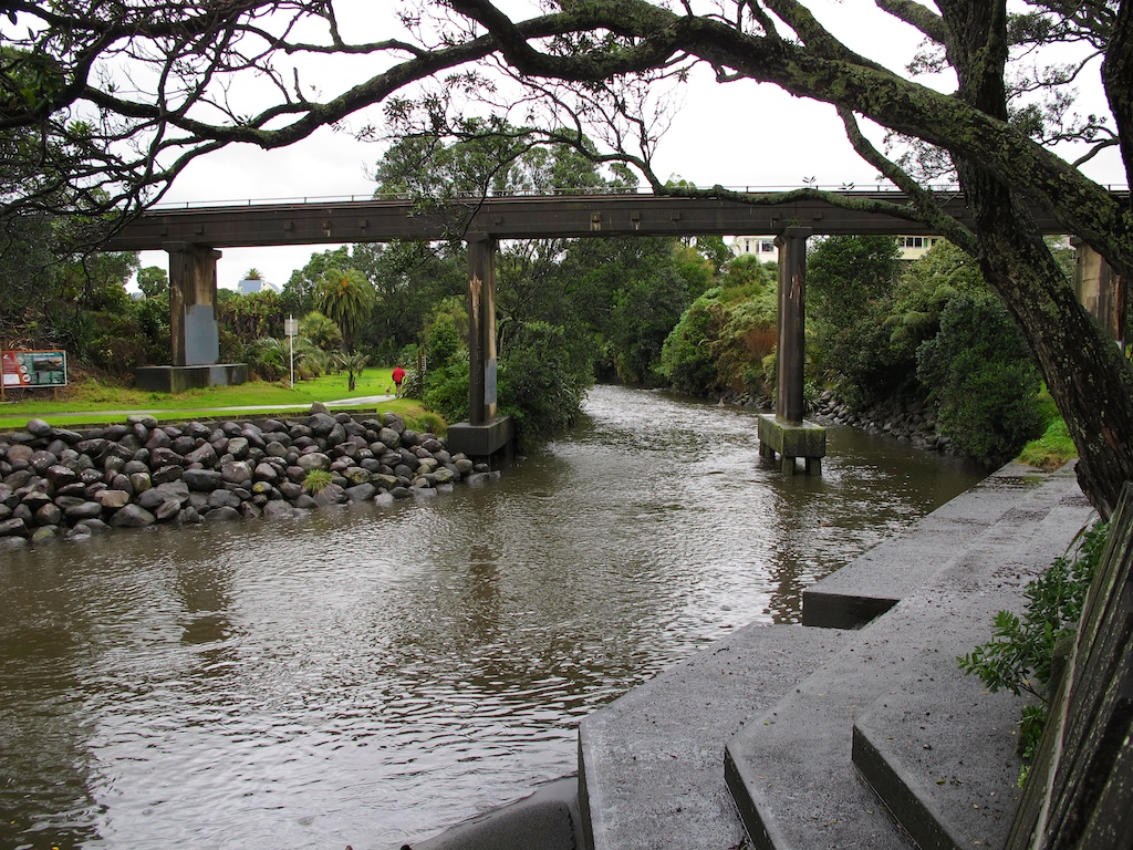
Last week we had a short holiday to visit our daughter and grandchildren in Auckland. We decided to make a detour via New Plymouth, so that we could ride the Coastal Walkway. This is an 11km stretch of wide, smooth concrete path along the waterfront, specially designed for walkers and cyclists. At the city end it runs along the top of a seawall, made up of large boulders. Further north, it skirts beaches, sand hills and farmland.

The seawall is made of large boulders (photo by John)

We had enjoyed walking much of this walkway on previous visits to New Plymouth, and thought it would be great to cycle along it. We needed just one day to cycle the track, so booked two nights in “The Urban Bach”, a delightful cottage, where we had stayed before, and which I can heartily recommend. 

I had been watching the weather forecasts all week, hoping that the heavy rain storms due to come in from the south, were not going to eventuate. We left Wellington in the pouring rain, but by the time we got to New Plymouth, in the late afternoon, it was almost fine. However, the nasty stuff returned overnight, and we woke to torrential rain. Fortunately by 11am, it had abated to intermittent showers, so we decided to brave the wet, and go riding anyway.

We parked near the port breakwater, right at the south-western end of the coastal track. As we were getting ready, a jogger coming off the track to return to his car warned us that there was a seal on the rocks by the swimming pool. He said it had given him "a hell of a fright", so we should watch out for it.

Getting the bikes ready for our ride

The track is super-smooth concrete – a pleasure to ride on. It is wide enough for walkers and cyclists to share, though today there weren’t many of either about. Despite the weather and dark-ish skies John took a lot of pictures.

The path is super-smooth. Len Lye's Wind Wand is on the right (photo by John)

Even with the jogger’s warning to be on the look-out for the seal, it took John completely by surprise. As we came round a corner near the swimming pool, it suddenly reared up, lunged at John as he was cycling past, and barked at him. John hadn’t seen it at all, so completely did it blend into the rocks. The boulders are dark brown and black and quite rounded – perfect camouflage for a fat, dark brown seal.

The seal is perfectly camouflaged among the rocks (photo by John)

I was behind John, so I saw the seal wriggling back down, and steered well clear of it on the far side of the track. Of course John parked his bike, and cautiously went back to take a picture of it. Seals can be quite nasty, so you don’t want to get up too close.

When we got close to the Wind Wand, it started to rain quite hard. John went down the ramp that leads to the underpass under the main road to cross towards Puke Ariki (New Plymouth's museum and library complex). I didn’t know why he went there, because the track continued across a bridge over a small stream. But it turned out that he just wanted to shelter under the bridge. I figured it was only water and we were wet already, so I carried on. He soon followed me.

It really wasn’t too bad, as there was no wind, and it was not cold. The track went along in front of a cliff face with beautiful sculptural textures. Sandstone, probably of volcanic origin, shaped by the wind and the water.

Sculptural textures on the cliff face (photo by John)

Past the Te Henui Stream, over the bridge towards the surf beach. Last summer there was a coffee-and-icecream caravan here, and a quirky row of old, but wonderfully comfortable, armchairs. No armchairs there now, of course, and no coffee caravan either.

In summer, there are comfy armchairs in which to enjoy a rest, a coffee and a gaze out to sea
(photo by John, November 2012)

On past the East End Surf Life Saving Club. When we got to the Fitzroy motorcamp, I stopped under a canopy to put my hood on under my helmet, as the rain was dripping into the slits in my helmet.

After the motorcamp, the track wound through the sand dunes – not much sand, but lots of flax and shrubs – very pretty. A few ups and downs, nothing I couldn’t cope with. Even so, my thigh muscles do find it very hard to go up any kind of slope, even a very gentle one. Maybe I should do some quad-strengthening exercises …

A wet, wriggly path in the sand dunes

Before long we saw the stunningly beautiful Te Rewa Rewa bridge across the Waiwhakaiho River. This is an award-winning bridge, built specially for the walkway, to connect New Plymouth with the town of Bell Block.

A little bridge, leading to the Te Rewa Rewa Bridge, in the distance (photo by John)

Its design is reminiscent both of an unfurling wave, and a whale skeleton. It is angled in such a way that on a cloudless day, you can see Mt Taranaki framed by its curving ribs.


John cycling on the Te Rewa Rewa Bridge

On a clear day, the bridge frames Mt Taranaki to perfection (photo by John, November 2012)

The rain had stopped by this stage, and of course we took photos, but Mt Taranaki was shrouded in clouds and mist. However, even on a dull day, the bridge makes an impressive statement.

View from the Te Rewa Rewa Bridge

We crossed the bridge and carried on along the track towards Bell Block. Through rolling paddocks, behind the sand dunes.Then along on a boardwalk amongst the flax, and to a look-out from where we could see the wide beach, and the sweep of the coast towards the city. It would have been nice to sit here and have a snack, but the seat was rather wet.

A nice place for a rest, but rather wet

The coastline towards the city, with Paritutu Rock and the Sugar Loaf Islands
(photo by John)
 
Then the track turned inland towards Bell Block, and we had to go up and down some rises, which I didn’t much like. I had to get off and walk a few times. A major hump turned out to be a bridge over an underpass for cows on their way to the milking shed. From the top, we could see the suburban houses, and also a small herd of cows. I was happy to turn around right here, but John wanted to take a closer look at the cows. They were actually heifers, I think – young animals anyway. The paddocks on each side of the track were very soggy indeed and there were quite a few puddles on the track too.

Cattle, soggy paddocks and large puddles (photo by John)
 
View towards the sea from the top of the hump

The sky kept changing from dark clouds, to actually showing some blue sky dotted with big white clouds, and back to threatening rain.

Changeable skies and threatening rain (photo by John)

On the return trip, after crossing the Te Rewa Rewa Bridge again, we deviated from the walkway to ride halfway around Lake Rotomanu, a small lake surrounded by beautiful trees and lovely picnic spots. We saw a gaggle of ducks and geese, all gathered together on the grass.

Lake Rotomanu (photo by John)

The jetty at Lake Rotomanu (photo by John)

A gathering of ducks and geese, and even a stray chook (photo by John)

Further along, back on the track, we stopped for a snack near the Surf Club, as it was sunny by now, but as soon as we sat down, we were targeted by the local sandfly population, so we hurriedly got back on the bikes. NZ sandflies are very small, but have quite a nasty bite, and they are very sneaky, as you don’t notice them until it’s too late.

The Māori legend about sandflies tells us that "the god Tu-te-raki-whanoa had just finished creating the landscape of Fiordland, it was absolutely stunning... so stunning that it stopped people from working. They just stood around gazing at the beauty instead. The goddess Hinenuitepo became angry at these unproductive people, so she created the sandfly to bite them and get them moving". It sure worked for us!

Near the Te Henui Stream bridge, another walkway goes inland, following the stream. We decided to see how far it would be possible to bike it.

The Te Henui Stream (photo by John)

To begin with, it was a smooth sealed path, which soon became a gravel track. It is a very pretty area – the stream, much fuller and swifter than it was back in November, a lot of beautiful trees, camellias starting to flower, and lots of tree ferns. We played tag with a woman walking her dog – we would pass her, but every time John stopped to take a photo, she would overtake us again. He takes his time with his photos, carefully framing each shot, making sure each is a pleasing composition.

Beautiful trees along the Te Henui Stream track (photo by John)

We rode about a kilometer before the path went over a little bridge, and then deteriorated to a muddy grass track, so we turned around. Suddenly the rain came down in buckets, but I was not game to shelter under one of the road bridges, as there was too much evidence of pigeons residing there. I would rather be rained on than “plopped” on by pigeons.

During heavy rain, water from the road above drains into the stream through a hole in the bridge (photo by John)

As we went past the cliffs again, I noticed that there was a gate, which could be swung across the track when the weather, wind or waves made it too hazardous for people to go there. I noticed too, that the noise of the waves rolling in was louder than it had been earlier in the day. The tide was coming in. On the top of the cliff, a house with a tower grabbed our attention. I would love a house with a tower. So romantic! And what a great view it must have.

If I were ever to move to New Plymouth, I'd want to live in the house with the tower (photo by John)

By the time we got back to the beginning of the Coastal Walkway, it had fined up again, and we thought we would ride to the end of the breakwater while the going was good. The surface was sealed but very uneven, and it was the hardest part of the day’s riding because the lumpy-bumpyness hurt my hands.

The surface on the breakwater was very uneven (photo by John)

The port and Paritutu Rock, seen from the breakwater (photo by John)

Then John decided we should bike to the end of the road to the port. We rode along the road for some distance, then onto a pretty little path among old pohutukawas. In the bark chips under the trees, I saw lots of strange white shapes – rather like tennis balls with bits cut out of them – which I suspect were mushrooms. Unfortunately I didn’t get a close look at them because as we got to the end of the path, it started to spit, and by the time we got back to the car, it was teeming and we were thoroughly drenched.

Pohutukawas

We put the bikes away in the car, and went to have a rather late lunch at the “Bach on Breakwater” nearby. We had ridden 29 kms in nearly three hours. The variable weather had made it really rather interesting. Still a very enjoyable ride. The bonus of the poor weather was that we did not have to share the track with anyone. It would be a very different experience at the height of summer, with walkers, families, tourists and cyclists, even “crocodile bikes”, all out enjoying the walkway and the sights. But it would be fun to ride the track in the sunshine, so we will definitely be back.

Twin bikes on the Te Rewa Rewa Bridge


Saturday 15 June 2013

Eastbourne and Pencarrow

Today is Saturday, and it’s already four days since we went for our last bike ride. We rode in Eastbourne on Tuesday afternoon, but I have been too busy to write it up.

It was calm and reasonably mild, though somewhat cloudy. The forecast for the rest of the week was not very promising (though they often get it wrong!), so at lunchtime I suggested we go for a ride before the weather packed up. A nice sedate ride on the flat would be just right, as I had already done some physical jerks at the gym in the morning. We don’t want to overdo things, now, do we? So we decided on the foreshore at Eastbourne.

Delightful marine-inspired decorations on this Eastbourne house (photo by John)

We parked at the entrance to Eastbourne, and set off down the road, heading south. Once past the wharf and the main shopping street, there is a lovely “promenade” between the beach and the houses, very pleasant riding. We had misjudged the temperature, however. Over on this side of the harbour, there was quite a chilly southerly breeze, and I had to put on the extra jersey I had brought with me, but John had to go back to the car to get his.

So while waiting, I loitered about, taking photos of the beach, and peering into people’s gardens. There are some quite interesting houses along there and some very nice gardens. I spotted a mosaic letterbox, a stone seat built into the wall facing the beach, some sculptures and carvings, stylish steps leading up to gorgeous gates. The aloes are out in full flower, in great mounds of orange spikes. I am not much of a gardener myself, but I enjoy looking at other people’s gardens.

Aloes in full bloom

It seems the residents make the beach their own, judging from the two garden seats I spotted on the pebbly beach in front of one house.

Someone's special seats with a view

We had to make a little detour into the pohutukawa-lined streets because we could not ride through the sports ground adjacent to the beach. The houses here are mainly beautiful well-maintained old houses, with a sprinkling of interesting, rather more modern houses.

One of the lovely Eastbourne houses (photo by John)

Back onto the promenade and then past the Eastbourne bus terminal, and a rather colourfully decorated bus shelter.

I love this bus shelter, especially its messages

Beyond the bus garage is the Wahine Memorial, which features one of the salvaged masts of the interisland ferry Wahine, which sank in Wellington Harbour on 10 April 1968, with the loss of 51 lives. Many bodies were washed up on beaches along this side of the harbour, and many of the survivors managed to land here, despite the rocks and the dreadful stormy conditions. On the opposite side of the harbour is Seatoun Beach, where other survivors landed. There is a Wahine Memorial Park there too.

The salvaged mast of the Wahine, at the Wahine Memorial

A little further on we got to the gate which provides access to the Pencarrow track. Though we had planned to ride just on the paved Eastbourne waterfront, I agreed to carry on “for a bit” on this gravel track.

Well, it wasn’t just “a bit” — we ended up going as far as the Pencarrow Lighthouse. It really is a beautiful area, and the gravel track wasn’t too heavy-going, so I didn’t mind. There were some potholes and puddles, but there was plenty of room to go around them.

Plenty of room to go around the puddles (photo by John)

The lighthouse is very elusive. The first time you see it, you think “not much further to go, it’s just around the next point”. But no, it’s not around the next point, nor the next, nor even the next after that. I lost count of how many bays and points we had to go around, but we eventually got there.

The Pencarrow Lighthouse (photo by John)

There is quite a bit of variation in the bays and beaches – some rocky and wild, others wide, smooth and empty, others strewn with driftwood. In some of the bays, in the lee of the hill, there wasn’t a breath of wind and it actually felt quite balmy, while a few dozen metres up the road, there would be a chilly southerly.


Some beaches were rocky ...

...others were wide, smooth and empty ...  (photo by John)
... and some were strewn with driftwood (photo by John)

On our way back, we saw the Interislander ferry Aratere heading out towards Cook Strait. Quite an impressive sight, silhouetted against the Wellington hills and the glistening water.

The Interislander ferry Aratere (photo by John)

Again, a satisfying ride, rather longer than we had intended – two and a half hours, instead of just one hour as planned. But it’s great to be able to take the opportunities as they come up, and this one was definitely a bonus.


Gorse flowers - soon the hills will be covered in gold!


Saturday 8 June 2013

Western side of the Hutt River - a mosly flat ride


Yesterday was another one of those “you-can’t-beat-Wellington-on-a-good-day” kind of days. Fine, crisp, no wind. What more would a (“flatlander”) cyclist want? A nice, trauma-free ride on a smooth, FLAT track? Yeah, I got that – well, mostly. There were a few ups and downs and a few muddy patches, but nothing to get my knickers in a twist about.

After our last three rides, during which I found myself having to struggle up hills pushing a bike, I declared that our next ride HAD to be on the flat. So we had another go at the Hutt River Valley trail. One of the sections we haven’t yet explored is on the western side of the river. We parked the car near the base of the Ewen Bridge, and headed up the valley on the stopbank.


A flat, smooth track on top, a gravel track below (photo by John)

We had ridden part of this track once before. It is beautifully smooth, and flat. I was happy! On this stretch of the trail there are two tracks: one smooth, tarsealed, on top of the stopbank; and the other gravel, further down, closer to the river. I was puzzled by a long pile of large rocks, stretching for maybe 30 metres. They probably came from the river, but didn’t seem to be part of a water defense system.

What are these rocks for? And what kind of trees are these?

Further up the track, the tarseal ran out and we rode on the gravel track. I was delighted to see two large kereru, NZ’s native woodpigeon, flying from the trees lining the riverbank to some pine trees further up the hill. They are large birds, and have a very lazy “flawp-flawp” way of flying. You can actually hear the flapping of their wings. 

Later, when we were on our way back through a bit of bush, another kereru flew overhead and settled in a tree right near us. He did not seem at all worried by us. We could clearly see his white chest, beautiful green throat, and red beak, feet and beady eyes. Quite special.

The kereru was not worried by our presence at all (photo by John)

Also along this bit of the track we saw dozens of Monarch butterflies, that seemed to have been clinging to the trees, and were disturbed by our riding past. Knowing precious little about butterflies, I would not have known they were Monarchs, but for the fact that I saw some photos taken by Michelle Sullivan on her blog “Christchurch Daily Photo". On 26 May, she posted some photos of Monarchs that are overwintering in Christchurch parks. It would appear that they do the same in the trees by the Hutt River. 

The track went underneath the Avalon Bridge, and we ended up in the Belmont domain, where we rode across a grass track. At the end of the domain we had to go through a gate, and the track became one of those things I have grown to dislike: up a bush-covered hill, narrow, stony and muddy by turns. Fortunately it didn’t last for too long, and soon we were out in the open again.

The gate to the bush track (photo by John)

Somewhere along here the track went quite close to some houses, and we were charmed to see a quirky garden, which, as well as having a vege garden and what looked like a large rabbit hutch or chicken run, had four doors standing up side by side, but not leading anywhere. Was it the beginning of a fence, or children’s play house, or chook run? There were some old cane chairs there too. It looked like a nice place to spend a summer’s afternoon, with a good book.

Puzzling doors in a charming garden (photo by John)

We had to cross a fast-running stream of water, coming from a big culvert on the uphill side of the track, and hurtling down to the river below. There was a little concrete ford, and John rode right through the water. He got wet, as the water splashed up around his bike. I decided to get off my bike and jumped across the narrow stream, leading my bike on the downhill side of me. But on the way back, I had the bike on the uphill side of me, and water splashing around the bike earned me a wet leg and shoe.

The ford where we got wet!

As we neared Manor Park, a sign told us that this was the end of this part of the Hutt River trail. We could pick up the trail again 3.8kms further up, but would have to ride on SH2 to get there, which we didn’t want to do. We did carry on a bit further along a poorly maintained road that was all lumpety-bumpety and full of potholes. There are a couple of tunnel-shaped sheds along here, one of them bright blue, that one can see from SH2, and I’ve often wondered what they were. They house machinery and vehicles. One belongs to a timberyard, the other seems to be a place where they collect – or hopefully recycle – old tyres.

Instead of going to SH2, we turned right, and thought that perhaps we could ride through the Manor Park streets and pick up the track again, without having to go on the highway, but we came to a dead-end at the Manor Park Golf Club. It seems to occupy all the land between the river and SH2 at this point, and that must be why the track petered out. Very selfish of the golfers, I reckon! We didn’t think they would appreciate us trying to ride across the golf course to get to the rest of the track, however, so we turned around. It was pretty much our half-way mark anyway, at nearly 10km from our starting point.

Manor Park Golf Club blocked our way, forcing our U-turn

On our way back, we circumvented the bush track by riding along some quiet suburban roads. Cherry trees in gorgeous autumn colours lined the street, fallen leaves hugged the edge of the footpath, and winter-flowering camellias in bloom towered over garden fences.

Back at the Avalon Bridge, we crossed to the other side of the river, to return along a path that is fast becoming one of my favourite stretches of track. The poplars along here are all bare now, as are the willows. There are some trees that I can’t identify (not that I’m any kind of botanical expert), that still have quite a lot of leaves on them. The trees are tall and straight, and the leaves are narrow and elongated. There are lots of these trees all along the river’s edge. It could be another type of willow perhaps. Can anyone enlighten me?

We got back to the car having ridden 21.5kms in just over two hours. A very pleasant ride, on another gorgeous day.

A crisp and clear winter's day - the shadows are growing longer, and there is snow on the Tararua Ranges in the distance (photo by John)

John tells me I should mention that Wellington does not have glorious weather all the time. Especially now that the winter is here, we do have some very nasty days. We just don't ride on those days. But so far, autumn and winter have been relatively kind to us – better in fact than in some other parts of NZ. Aucklanders especially like to sling off at Wellington, and mock us for our weather, but this year we’ve been better off. Let’s hope it continues.


Sunday 2 June 2013

Upper Hutt


I had not planned to go cycling at all today. It was fine-ish, but quite windy. At lunchtime, John said, “according to the online weather report it is not very windy in Upper Hutt. Let’s go to Harcourt Park and ride the loop from there”.

About three weeks ago we got as far as Harcourt Park on the Hutt Valley Trail, and turned left after crossing the footbridge. So this time, having left the car at Harcourt Park, we turned right. Nice wide gravel track, a sign post with a map of the track: “Oh yes, we can go here, and then across the bridge and come back along here”. Looking good!


The footbridge and map of the track (photo by John)

Yeah right! The track goes round a bend, and what do you know? It deteriorates into a skinny, STEEP!, rocky track, through bush. Ever so pretty – that’s if you like climbing and pushing a bike uphill, which I don’t!


So far, so good. But a nasty surprise is just around the corner! (photo by John)


We climbed for a while, with me puffing and panting and cussing. I was all ready to turn around right there and then. “It’s not far, look, it’s starting to even out over there” said John. Yep, it went downhill OK, but still very narrow, and on gravel. My riding is not very steady in places like that, and it was hard on my hands trying to keep to the track.

Whew, I heaved a sigh of relief when the track ended at a suburban back road, Bridge Road. Much more pleasant riding. Time to enjoy the autumn colours on the trees. The Hutt Valley has more deciduous trees and autumn colours than Wellington. The notorious Wellington wind tends to rip the leaves off before they get a chance to colour. Now that there have been a few very cold days and nights, especially in Upper Hutt, the colours have really intensified, and the golds, oranges and reds are quite gorgeous.

We rode along Bridge Road, till we got to the bridge over the Akatarawa River, close to where it joins the Hutt River. Looking up valley from the bridge, the dark greens of the bush, and the gathering clouds, made for a somewhat sombre view. The valley is quite rugged, and its main claim to fame is the Staglands Wildlife Reserve. We haven’t been to Staglands for years, not since our children were small in fact. Back then, it was a great place to go to with kids. It probably still is, but with a better café.

The Akatarawa River


After the bridge we turned right. John checked out the “track”, but it looked like it was going over a rough-surfaced stopbank, and he thought it would be better not to take that option (in view of my grizzling, no doubt). So we rode down Gemstone Drive, which runs parallel to the riverside track, but a street away from it.

All the side streets along here are named after gemstones, and in alphabetical order too – Amber, Beryl, Crystal, Garnet, Jasper, Ruby, Sapphire and Topaz. There even is a subdivision called Emerald Hill. Very cute. And I really like the Upper Hutt street signs, which are green and white, and all have a picture of a fantail on them. The fantail, a delightful New Zealand native bird, is the symbol for Upper Hutt.

This street ended up at the main road, SH2. We had to go north to rejoin the track, but we had to ride a little distance on the main road, which worried me, because it is a very busy road. But before long we were able to get onto a little track which was separated from the road by a low barrier. A little safer, but a HORRIBLE track! As it moved away from the road, the track skirted the river again, but there was a drop down to the water's edge.

Moss-covered rocks along the bush track

It was slippery gravel, and narrow, and I found it very hard to keep my balance. As mentioned before, my riding is not very steady on such surfaces, and my front wheel would want to veer off the track, while my body would try to regain its balance, and my hands, which were already quite sore, would desperately try to keep a good grip on the handlebar and especially the brakes.

John’s very sympathetic comment was “Well, at least there’s plenty of blackberry to catch you before you fall down the bank”. Nice! Blackberry is another one of those noxious weeds, that are full of vicious thorns.


"Plenty of blackberry to catch you" (photo by John)


Several times I had anxious moments which triggered a paranoid panic reaction — a remnant of traumatic childhood experiences. My breath catches, and my heart lurches, and my voice wants to shriek “No!”.

When I was quite young, we would go and visit my grandparents in the Netherlands. They lived on a road that had “sloten” on each side, and the house would be reached by a little bridge across the “sloot” (pronounced "sloat"). I know of no adequate English translation of “sloot” – it is a waterway, somewhere between a water-filled ditch and a narrow canal, and Holland is full of them. Well, as we arrived at my Oma and Opa’s place, my mother would insist on doing a three-point turn (or maybe more) on this narrow little road between two ditches, so as to point the car in the right direction for the return journey. Our car was a little Hillman (I think) with jerky gears that would make the car jump forward. My sister and I would be terrified of ending up in the ditch, and would screech in panic. We never did end up in the ditch, but the panic stayed. I still, after nearly sixty years, have these feelings of panic whenever I go too close to a ditch in a vehicle, and now on a bike. Pathetic and totally irrational, I know, but still very real to me.


My grandparents' house in winter (1950s), seen from the frozen canal. The road runs on top of the stopbank in front of the house, and there was another ditch between the road and the hedge. The house had "sloten" all around it, a little island in fact.

Eventually the track went down through an underpass under the main road, onto a nice bit of road, and over another little bridge across a stream. Unfortunately this was only a short loop off the main road, and we were soon back on SH2. John checked the way ahead, but decided it was too hazardous, so we turned around and went back the way we had come.

Cute little bridge

Back along Gemstone Drive, and left onto Akatarawa Road. Then, yay! A dairy, with a big Tip Top sign! Tip Top means icecream cones, so we stopped to have one. Hokey-pokey, of course. I reckon I had deserved that!

Your typical New Zealand dairy

It wasn’t far from there to Harcourt Park, where we arrived back at the car, just as it started to drizzle. Nicely timed.

Gorgeous autumn colours in Harcourt Park (photo by John)

Maybe I’m a total wuss, but our next ride will have to be on the FLAT and predictable! I simply do not understand how mountain bikers can do what they seem to enjoy so much – throwing themselves off steep, slippery, bumpy, hazardous tracks, risking life and limb, just for the thrill of it! Am I showing my age here?